

SAR Track app for iPhone and iPad
Developer: ezaero, Ltd.
First release : 21 Jan 2014
App size: 6.46 Mb
SAR Track is the best app to use on a mission to keep an easy, accurate, real-time log and provide a detailed debriefing.
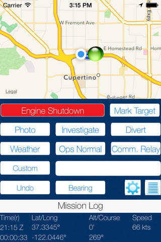
• Displays the track in real-time
• Captures the time, Latitude/Longitude, altitude and course for user-specified events with a single touch
• Annotates the map with events
• Custom log entry can be made at any time
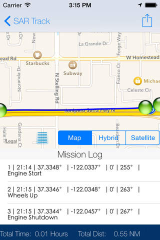
• Review the sortie in detail on the device or share via e-mail and import into external mapping tools.
• Universal app runs on both the iPhone/iPod and iPad
=================
In the Air
=================
MISSION OBSERVERS no longer have to write down sortie events. Setup your buttons to capture standard events like: In Grid, Ops Normal Checkin, RTB, Investigate, Divert, Photo, Mark Target, Weather, Communications Relay, etc. Observers will appreciate the decrease in their workload so they can focus more outside the cockpit and spend more time on sortie objectives. Theyll finish the mission with a complete and accurate log of mission events that will impress any customer or debriefer and help them make better decisions to complete the mission.
MISSION CHECK PILOTS and INSTRUCTOR PILOTS can use it during flight to take notes and provide real-time feedback. When the flight is complete, the entire flight can be reviewed without having to remember or write down what happened.
=================
On the Ground
=================
GROUND TEAM LEADERS and GROUND TEAM MEMBERS will utilize the logging of their track and the ability to take notes along the way. Easily mark events like where beacons were picked up, where clues were found, when communications were made, etc.
=================
At the Debriefing
=================
INCIDENT COMMANDERS, AIR OPERATIONS BRANCH DIRECTORS and CREW MEMBERS will love how it enhances debriefings by graphically displaying the route taken during the mission and annotating all mission events. The map can be zoomed in and analyzed in a number of ways. The log can be e-mailed and imported into various mapping tools like Google Earth, opened directly in compatible apps on the iPad, or exported in standard GPX and KML formats. Air Sorties and Ground Missions are colored differently so combined tracks can be easily distinguished.
================
Features
================
● Constant display of time, Latitude, Longitude, GPS Altitude and Magnetic Course
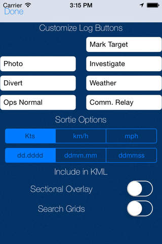
● Nine customizable log buttons (seven on iPhone) to make logging common events a breeze with one touch
● Map and track is displayed and updated in real-time to review accuracy of maneuvers enhancing situational awareness
● Mission Log captures Log Number, Time, Latitude, Longitude, Altitude, Course, and Event every time an event button is pressed
● Debrief View shows route, event annotations, and complete log to facilitate sortie discussion
● Route and event information is interoperable with other iPad apps compatible with GPX or KML formats (i.e. Google Earth) and can be reviewed in an immersive 3D depiction of the sortie
● GPX or KML files can be shared through e-mail along with mission log
● GPS Track is logged in the background so you are free to utilize other apps during flight
● Use internal or external GPS
● Automatically logs wheels up and wheels down. Flight ends automatically if you forget.
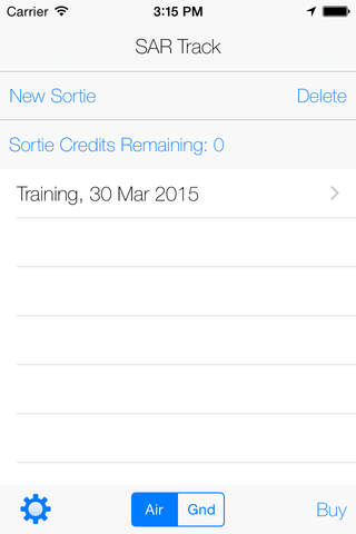
● Flights are saved and can be reviewed at any time.
● Supports Metric and Imperial Units and three standard degree formats
● Select Ground or Air mode when starting mission
● Auto-zoom to event in debrief mode
● Mission timer
Disclaimer: Continued use of GPS running in the background can dramatically decrease battery life.